Thursday, September 10, 2009

San Jacinto Peak

August 29th, 2009 :- I had been thinking about hiking to Mt San Jacinto for the past year and a half but had not got a group to come along. Ashish had planned a trip to San Diego and agreed to hike to the second highest peak in Southern California. Fellow cricketers, Srinivas, Narasaiah and Shiva also were eager to join us on this challenging hike.
Mt San Jacinto rises 10,000 feet from the desert and is a short drive from Palm Springs. Due to the abrupt rise of the San Jacinto mountain, it has been referred to as an "Island in the Sky". The peak is at a height of 10834 feet above sea level. The route to the top of the peak from Humber Park at Idyllwild is 7.6 miles (one-way). The other easier route is from the Mountain Station of the Palm Springs Aerial Tramway, a distance of 5.5 miles. We decided to drive to the Valley Station of the Palm Springs Aerial Tramway, located at 2643 ft above sea level. Mountain Station is located at 8516 ft above sea level and requires one to take the aerial tramway. The hike to the top of the peak thus requires an ascent of about 2318 feet along a trail of 5.5 miles starting at Mountain Station.

We left in two different cars at close to 7 am, although we had planned to leave at 6:30 am. We reached Valley Station close to 9 am and got tickets to the very next tram that departed in the next 5 minutes. A spectacular 10 minute, 2.5 mile trip along the aerial tramway is quite an experience. During the ascent one passes through five unique life zones from the Mexican Sonoran Desert to an Alpine wilderness.
We registered our information at the ranger station that is a short distance from the Mountain Station and lies along the hiking trail. We began our hike at about 9:50 am and going by hiking blogs and experiences of other hikers, we expected to get to the top in about 2.5 to 3 hours.
The first marker of this trail is Round Valley, located at 9100 ft above sea level. A hike of 2.2 miles takes one to Round Valley, a picturesque opening in the wilderness with an expansive meadow at the centre. It took us an hour to get to Round Valley. Srinivas and Ashish were in the forefront on this initial leg of the hike. Srinivas, seemed to be a fast hiker and set a fast pace, inspite carrying a gallon of water and other food stuff in his back pack. Ashish too, seemed to be going along fast, inspite his lack of frequent hiking trips.


Tom, a forest officer checked our permits and advised us about not drinking the cold water coming out of an ever-flowing tap at that checkpoint. The weather was pleasant and we felt much more comfortable, than we would have, had we been outdoors in San Diego or even had stayed at home. The weather in San Diego during that entire week had been unbearable and the demand for power had increased rapidly. A frequent urge to drink liquids resulted in us emptying a few bottles of Gatorade in the first part itself. Our progress was not too brisk but all seemed doing well.

The next stop would be at Wellman's divide, located at 9700 ft above sea level. Although, it was just a mile away, this distance required an ascent of 600 ft and turned out to be quite a challenge. We required more than two breaks along the way and it took a complete hour to get to this opening. At one particular point, I was completely out of breath and my heart was pounding harder than I had experienced off late. Although, we had passed many a hiker along the way this was one point where there was a big gathering of hikers of all ages. The hike from Humber Park connects at this point and quite a few groups fancied the location as a point to rest. We took the oportunity to click few photographs and grab a bite and get some rest.

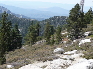
We still had 2 miles to go before we could hit the peak and another 1150 feet of ascent was pending. The hike from here seemed steep and looked like a challenge for a tired hiker. The path took us along the edge of a mountain and provided good views of Round Valley and the Mountain Station area.
Within the next minutes we had to take a break as the terrain was demanding in an area between two ridges. Ashish and I, continued after a brief break and very soon the switchbacks began along a ridge that turned out to be the one that would eventually take us to the peak. These switchbacks were quite demanding and fairly steep. The mountainside at this point was pretty picturesque with extensive views down into the desert valley below.

We made it to the top of the ridge and approached a marker indicating the peak was only 0.3 miles away. The thought of making the final ascent to the peak resulted in us trudging along within a few minutes of having a much wanted drink. The winter shelter is very close from this point and has good shade around it. Groups of hikers on the way up and down used this spot for rest as well as a place to have a meal. We went inside the shelter to see what it had to offer for a tired hiker, held back by bad winter weather. The shelter seemed strong enough to braze a storm. It had a couple of multi-level beds and few other items for display from older times.
Then began the final scramble to the top. This area is laden with rock of all sizes, mostly large ones. One has to find ones way along or between these rocks as one is comfortable with. There is no trail in this final leg and the top is also mostly rocky. There it was, the top of Mount San Jacinto, a mightly 10,834 feet above sea level. Ashish and I, were the first among our group to get to the top. Srinivas followed next and Narasaiah and Shiva made it within a few minutes after Srinivas. Standing at this height was a thrilling experience and the view down into the desert valley towards the East, about 9.5K to 10K feet below, was one I have never seen before.


Quite a few groups made it to the top, certain others had isolated themselves to different corners of the rocky mountain top, enjoying the views of the desert valley. There are two reference markers by the US Coast and Geodetic Survey. The sign indicating the place and height of the
peak was a popular spot, as every one making it to the top wanted to click a photograph. We were the only group that spent considerable amount of time enjoying the moment and the views in the directions that were open.

Finally, we left the top and stopped immediately at the shelter and took some rest. Later, we munched on to the snack that we had got with us. The walk down began with the 2 mile stretch along the steep slope that offered splendid views upto Mountain Station and the valley beyond. On the way back we first stopped at Wellman's Divide after having completed 2.3 miles of a stretch. My head got a bit heavy along this stretch and this was the first sign of me getting affected by altitude. We then decided to take another halt after Round Valley knowing we had 3.2 miles to go before we could get to Mountain Station. Ashish and the others went along at a rapid pace but I trudged along slowly, not only because of me being tired but also due to the excitement having gone down.

We reached Mountain Station around 5 pm. The final ascent, at the point close to the building at Mountain Station was quite demanding given how tired the entire group was. We had to drop a copy of our permits in a drop box at the Ranger Station. We let a tram go by, but we took the time to rest and grab a bite. Within 20 minutes the next tram departed, with us on it. We left immediately after getting to the bottom and experienced the heat of the desert valley as soon as we entered the car. It is said that on any given day the mountain top and the desert valley experience a temperature difference of 25 to 30 deg F, and this day was no different.
The experience to the second highest peak in Southern California was one to remember for long and quite an achievement for infrequent hikers like us.

Mt Baldy, Mt Giorgino are other mightly mountains in Southern California that beckon ..

http://picasaweb.google.com/ahire.parag/HikeToMtSanJacinto?authkey=Gv1sRgCM-w39WOkLWbyAE&feat=directlink

No comments: