Sept 7th , 2009 :- The hike on the previous day was tiring but even then I managed to get started early at about 8:30 am. The plan for the day was to drive the 48 mile distance through the park along CO-34 and exit the park at the Kawuneeche Visitor Center on the Western side.
This time, I entered the park from the Fall Visitor Center on the East. The views of the meadows from Sheep Lakes were pretty enticing. Beyond this point is the Old Fall River Road, a distance of 9 miles that winds its way up to Alpine Visitor Center. It is a dirt road and although I was tempted to drive along, I decided to avoid it since getting into trouble with a problem with one of the wheels could have caused substantial delays.
I then headed along CO-34 without any halts and made it to Medicine Bow Curve, that is just beyond the Alpine Visitor Center. The road from here drops down over the mountains. A short distance away is Milner Pass that goes through the Continental Divide. Poudre Lake on the North feeds a river system that eventually connects to the Mississippi River than drains into the Atlantic Ocean. Beaver Creek, just to the South feeds the Colorado River that empties itself into the Colorado River. A guide sitting there made it a point to draw the attention of children to this interesting fact. With a few halts along the way and enjoying the scenery, I made it across to the Kawuneeche Visitor Center.
I watched a 20 minute movie about Rocky Mountain Park. The movie was good and informative but unlike some of the other movies that try and depict the park as "the place" on earth this one seemed pretty modest about its message. This also seemed like an old production and probably needs to be replaced by a newer version. I munched on a few snack items and spent time around the visitor center in order to catch the movie at 1:15 pm about the Colorado River. This mighty river originates within the park boundary and flows pretty close to CO-34 through this part of the valley. It was a lengthy movie, but I was reluctant to leave until it was over.
I started at 2 pm and decided to hike to a waterfall named Adams Falls that was close by next to Grand Lake. Grand Lake and Lake Grandby are two lakes that the Colorado River flows through and are close to each other and also pretty huge in size, the latter being the larger of the two. Adams Falls was just 0.3 miles from the trailhead. Knowing, I had to get to Denver at about 5 pm I made it to and back from the falls in quick time. I had been forewarned about the traffic slowing one down on the way as one gets close to the city.
On the way back the 46 miles distance along CO-40 prior to Idaho Springs turned out to be the one where progress was the slowest. Traffic down the hill had a single lane and if you have a slow moving truck ahead of you, you are done. Worse was to follow at US-70 where traffic was crawling at speeds of about 15-20 mph. Just South of Idaho Springs is Mount Evans located at a height of 14260 ft above sea level and one can drive all the way to the top. Had I made it quick all along during the day I just might have been able to drive to the top of this mountain.
I did make it close to Denver a little after 5 pm but the airport was ahead and almost 12 miles away from the freeway. By the time I dropped the rental car and made it by a bus to the airport, there were only about 35 minutes left for the flight to depart. Since it was less than 45 minutes for the flight, I was not in a position to check in the luggage. I made it to the gate of departure 5 minutes prior to the flight departure time and was among the last dozen odd individuals to board the plane.
Rocky Mountain National Park is the epitome of a visit to the mountains in North America. It was a wonderful experience and as usual the time available at hand proved to be not so adequate. This visit was certainly one to be cherished, the drive along Trail Ridge Road and the hike to 'Sky Pond' being the highlights of the time spent here.
Tuesday, September 15, 2009
Rocky Mountain National Park (Day 2)
Sep 6th 2009 :- The plan for the day was to hike in the Bear Lake area. The area around Glacier Gorge near Bear Lake is considered to the prettiest part of this park to head to on foot. As I was to hear from a hiker, later in the day, it is the equivalent to Ansel Adams Wilderness in the Sierra Nevada region.
I had checked out my options for hiking on the previous night itself. The hike from Glacier Gorge to either "The Loch Vale" (3.1 miles, oneway) and/or Mills Lake (2.8 miles, oneway) seemed to be my preference. I first headed towards Long's Peak trailhead along CO-7 but stopped first close to Lily Lake. It was a small lake but the reflection of the mountains in the lake was pretty enough for one to resist capturing it on film. Lily Mountain rises to 9786 feet but I had higher places in mind for the day. On the way along CO-7 the drive through Tahosa Valley brings one to a point where Long's Peak can be seen the best. It appears within ones reach but is an arduous 4000 ft climb from the trailhead.
Although, climbing it was a tempting proposition, I knew that it wasn't my destination for the day. On the way back I stopped for a few minutes at Mary's Lake. Bear Lake area is usually crowded and hence there is bus that takes one close to this area from a parking lot a few miles away. I made sure I was carrying enough food, water and other gear for the day. We had been warned of afternoon showers which are a norm here in the mountains. Hikers are encouraged to complete their hike so that they are done by 3 pm or so.
Glacial Gorge trailhead is located at 9240 ft while Bear Lake is a few hunderd feet higher. The first point to get along the hike is Alberta Falls at a distance of 0.8 miles. It was the beginning of September and the faint traces of fall colors were visible from the trailhead. The trail upto Alberta Falls was pretty wide and was well manicured. Quite a few passengers on our bus joined this first part of the hike making it a crowded trail. Another trail from Bear Lake joins this trail and continues forward. Aspen and Pine trees abound in this initial part of the hike. Quite a few visitors were enjoying the view of Alberta Falls. Beyond the falls, only the serious hikers continue as the trail becomes narrower. One reaches the junction of North Longs Peak trail junction. At this junction one can see the expanse of the meadows and the mountains beyond. Also visible in the trees below is the colored vegetation of early fall.
One has to then continue right i.e south-west where one enters a valley between Thatchtop Mountains (12668 ft) . This point was very spectacular reminding one of the valley in Yosemite. At the 2 mile mark is the junction of the routes to Mills Lake and the Loch Vale. From this point it is a rather steep, 1 mile climb towards Loch Vale. One first approaches a narrow creek where a few switchbacks begin. Upon climbing this part of the mountainside one reaches the flatter top to reach the The Loch Vale. The vegetation here is primarily that of the evergreen forests.
Although, I had decided to get only to Loch Vale the prospect of going higher towards Sky Pond and closer towards Taylor Peak (13153 ft) was too tempting. The trail from Loch Vale passes from the North of the lake towards the east and then through some swampy area. There are a few spots where one needs to pass over wooden logs placed over creeks. The next landmark is Timberline Falls where it gets slightly tricky to pass along. The falls are about 50 feet high and are split into two parts. At the western edge of the falls is a ledge that needs to be traversed to get to the top. After a scramble over the ledge one immediately gets a view of Lake of Glass on reaching the top. The vegetation here quickly changes to that seen in the alpine tundra. The weather here is harsher and not much vegetation survives. The lake is supposed to have some trout. A angler hiked this last stretch with his fishing pole and indicated he had seem bodily remains of a bear on his climb from Loch Vale. He had not taken the trail but I did get stopped in my tracks by a badger or beaver who crossed the trail right in front of me.
A short walk ahead from the Lake of Glass is Sky Pond. The Taylor Glacier can be seen right across the Pond. The Sky Pond is located at 10900 ft above sea level, meaning I had completed an ascent of 1660 feet from the trail head. The hike had been tiring but the ever changing scenery had almost cast a spell. Along the way, I had passed two waterfalls and this was the third alpine lake beyond which views of a glacier were on offer. It was hard to imagine that the Taylor Peak was still 3000 feet higher up. Cathedral spires of the gash could be seen towards the Northern side beyond which was the area near Andrews Glacier. The hike to Andrews Glacier was steeper although it was just half a mile longer and hence I had opted to get to Sky Pond from The Loch Vale.
I spent quite some time absorbing the views down towards the Loch Vale and lower down through the narrow opening in that direction. This was one of those hikes where the scenery over 4.5 miles was spectacular and was one of amazing variety. I did spend some time having snack and then headed down over the tricky part of the route over the ledge next to Timberline Falls. It wasn't as tricky as say Harishchandragad but nevertheless not one of those common trails in a national park.
As I got close to the Loch Vale it got cloudy and soon a drizzle began. Fellow hikers who were prepared got their rain gear out, others were carrying ponchos. The vegetation was thick enough and I found a spot under a tree where the light rain hardly got to me. The drizzle did not last too long and I continued down the switchbacks and to the junction to Mills Lake. My earlier plan was to get to Mills Lake after having come down from the Loch Vale but that was when I had no intention of going up towards Sky Pond. A short halt here and I proceeded down knowing there were 2.2 miles to go.
I headed back to the Glacier Gorge area and intended to get to Bear Lake not knowing that one requires an ascent to get to Bear Lake from Glacier Gorge area. Fortunately, I did notice this just at the right time and hence I headed to the parking lot at Glacier Gorge trailhead. A short bus ride took me to Bear Lake. I intended to go around in the lake area but I had to change plans as a big storm quickly approached and engulfed the area next to the bus stop. The rain started pelting and I started thinking about hikers who were heading to the top of Sky Pond while I was on the way down.
Upon coming to the parking lot, I spent some time inside the car waiting for the rain to slow down while I ate some snacks. After a while, I began driving without the rain having slowed down to a halt. As I got closer to Moraine Park, the rain had almost stopped. There were plenty of elk in the meadows and even more visitors trying to observe their behavior. I spent some time observing the elk, waiting for the sun come out in all glory but with the cloud cover towards the west that did not seem a possibility.
The 9 mile hike had taken its toll and although it was just close to 5:30 pm, I decided to head back to the hotel. The fall foliage, with aspen and pine trees to begin with, followed by evergreen trees and topped by alpine tundra made this hike one to remember for long. The views were further complemented by two waterfalls, three alpine lakes, a glacier and the jagged snow capped peaks of the Rocky Mountains an it was worth the hike to and fro.
Monday, September 14, 2009
Rocky Mountain National Park (Day 1)
Sept 5th, 2009 :- Rocky Mountain National Park is located in the state of Colorado and is truly a land of superlatives. There are at least 60 mountains exceeding 12000 feet in height in its 416 square miles of wilderness. Rocky Mountains extend for 2700 miles from Mexico to Alaska and is the longest mountain barrier in the world. More than one-third of the park is above the treeline, i.e above 11400 feet above sea-level. A road known as the Trail Ridge Road passes through the park and is the highest pass-through road in the world passing at a height of 12183 feet at its highest point. The road provides easy access to the alpine realm within the park boundaries without requiring a hiker to climb thousands of feet.
I started the 80 odd mile drive, from the Denver airport area slightly after 9 am. A halt for breakfast, then another at a grocery store in Boulder Colorado and the ocassional slowness in traffic resulted in me getting to Estes Park close to noon. The drive on the eastern side of the Rocky Mountains gave an idea of the relatively gentle slope on that side leading to the plains. The western edge of the mountains are steep and rise high from the desert below. Lake Estes seemed to be buzzing with leisure activity. Traffic through the hills on the way to Estes Park increased as speeds slowed down due to the mountain drive, and it was also an indicator of this being a long weekend.
I tried checking into the hotel but apparently the rooms were not ready. I did get the room keys but left for the National Park without moving my luggage into the allotted room. The small town seemed crowded for the weekend and traffic had slowed down. A few miles into the park from Beaver Meadows Entrance Station a hold up in traffic suggested some animal sighting. A lone elk was grazing in the meadow by the sides and that was enough to hold traffic in both directions.
It was partly cloudy given it was early in the afternoon, a time that storms usually develop in the high mountains in summer days. At a short distance is Hidden Valley where I spent some time eating the snacks I was carrying.
Just beyond is the "Many Parks Curve" point offering splendid views of Moraine Park in the valley below. Beyond the valley was a chain on mountains, topped by Long's Peak that rises to a height of 14,259 feet above sea-level. This is a challenge to climb requiring a hike of 8 miles from the closest trailhead. The climb to the top is a technical one for most of the year except a brief period in summer when one can get to the top of this mountain without actual climbing gear. the mountain top is as big as a football field and reaching the top is a sense of achievement for many a mountain climber. Quite a few fatalities have occurred in ascents to the top of this mountain over the years.
CO-34 passes through the park and is a stretch of 48 miles requiring 2 hours to go through. The section of the road known as the Trail Ridge Road begins at the next point known as Rainbow Curve. Pretty views of the Horsehoe park are visible from this point, the highlight being the meandering stream or river flowing through the meadow below.
The treeline is just beyond Rainbow Curve and one can see the sudden decrease in vegetation. The first close views of snow on the mountain sides was visible from this spot. The climate being harsh results in only specialized plants and animals thriving at this altitude, in an ecosytem known as the Alpine Tundra.
A short distance away is the point known a Forest Canyon providing views of the Trail Ridge Road that rises further ahead by another 500 to 800 feet on one side and the couple of thousand feet of drop in the canyon below. Glaciers beyond the valley below were clearly visible and these mountains also form what is known as the Continental Divide. The Rockies stretch North-South and hence play a role in the drainage system that directs water on one side to the biggest river on the East, the Mississippi & the biggest river on the West, the Colorado. In fact, the Colorado river originates within the western part of the park. It was extremely windy in this area exposed to the elements of weather on all sides. The wind chill forced many a traveller to bring out their cold-weather attire. Those that were dressed scantily had to bear the brunt of the wind-chill. For a brief period at this point I was wondering how I always manage to leave the necessary gear like leather gloves and monkey cap at home. Not many were ready with this kind of gear and that made me feel better in terms of my ability to be prepared. This seemed to be the perfect spot for photography but the harsh wind dampened ones spirit to an extent.
Just a short drive ahead was the Tundra Communities trailhead at Rock Cut point. Although, it seemed to be the highest point on the road from the previous spot, it was clear that the actual highest point was further ahead. It got really cloudy and within a short time hail/snow started falling that sent all travellers straight into the car. This did last for about 15 minutes and was evidence that the weather in the mountains, at this altitude is very unpredictable.
Closeby is the Lava Cliffs point, from where I witnessed a rainbow in a direction towards the North. Down in the valley in the same direction, I could see some wild animals (mostly elk or mule-deer). Lava cliffs true to their name are volcanic cliffs. A small body of water below had a buildup of winter snow beside it.
The road on either side was lined with slender trunk of tall trees. Apparently, this helps in identifying the road when snow piles about 20-25 feet in the winter months. Before, I could realize it, I had passed the highest point along the road just before the turnout for Gore Range.
Beyond this point the road drops down after the Alpine Visitor Center. It was close to 5 pm and it was getting a bit cloudy on the western side. I grabbed a coffee at the visitor center and then headed on the 0.3 mile Alpine Ridge Trail. A 300 feet ascent takes one to the 12005 feet height mark providing spectacular views in all directions.
On the way back, I did stop by at a few points to observe the mountains, glaciers and valleys lit with the evening sunlight. Long's Peak was glowing in the light even though it was partly cloudy. A brief halt at Forest Canyon resulted in a sighting of a herd of elk that sat lazily after having spent the day out grazing. As I descended down into the meadows area, sightings of deer and elk increased as it was the time that they usually come out for their evening meal.
My plan for the next day was to head out to the Bear Lake area that offers plenty of opportunities for hiking.
Thursday, September 10, 2009
San Jacinto Peak
August 29th, 2009 :- I had been thinking about hiking to Mt San Jacinto for the past year and a half but had not got a group to come along. Ashish had planned a trip to San Diego and agreed to hike to the second highest peak in Southern California. Fellow cricketers, Srinivas, Narasaiah and Shiva also were eager to join us on this challenging hike.


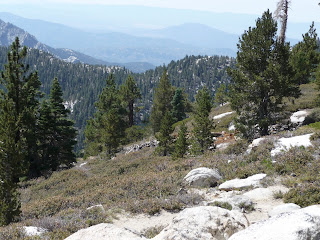
Mt San Jacinto rises 10,000 feet from the desert and is a short drive from Palm Springs. Due to the abrupt rise of the San Jacinto mountain, it has been referred to as an "Island in the Sky". The peak is at a height of 10834 feet above sea level. The route to the top of the peak from Humber Park at Idyllwild is 7.6 miles (one-way). The other easier route is from the Mountain Station of the Palm Springs Aerial Tramway, a distance of 5.5 miles. We decided to drive to the Valley Station of the Palm Springs Aerial Tramway, located at 2643 ft above sea level. Mountain Station is located at 8516 ft above sea level and requires one to take the aerial tramway. The hike to the top of the peak thus requires an ascent of about 2318 feet along a trail of 5.5 miles starting at Mountain Station.


We left in two different cars at close to 7 am, although we had planned to leave at 6:30 am. We reached Valley Station close to 9 am and got tickets to the very next tram that departed in the next 5 minutes. A spectacular 10 minute, 2.5 mile trip along the aerial tramway is quite an experience. During the ascent one passes through five unique life zones from the Mexican Sonoran Desert to an Alpine wilderness.


We registered our information at the ranger station that is a short distance from the Mountain Station and lies along the hiking trail. We began our hike at about 9:50 am and going by hiking blogs and experiences of other hikers, we expected to get to the top in about 2.5 to 3 hours.
The first marker of this trail is Round Valley, located at 9100 ft above sea level. A hike of 2.2 miles takes one to Round Valley, a picturesque opening in the wilderness with an expansive meadow at the centre. It took us an hour to get to Round Valley. Srinivas and Ashish were in the forefront on this initial leg of the hike. Srinivas, seemed to be a fast hiker and set a fast pace, inspite carrying a gallon of water and other food stuff in his back pack. Ashish too, seemed to be going along fast, inspite his lack of frequent hiking trips.


Tom, a forest officer checked our permits and advised us about not drinking the cold water coming out of an ever-flowing tap at that checkpoint. The weather was pleasant and we felt much more comfortable, than we would have, had we been outdoors in San Diego or even had stayed at home. The weather in San Diego during that entire week had been unbearable and the demand for power had increased rapidly. A frequent urge to drink liquids resulted in us emptying a few bottles of Gatorade in the first part itself. Our progress was not too brisk but all seemed doing well.


Tom, a forest officer checked our permits and advised us about not drinking the cold water coming out of an ever-flowing tap at that checkpoint. The weather was pleasant and we felt much more comfortable, than we would have, had we been outdoors in San Diego or even had stayed at home. The weather in San Diego during that entire week had been unbearable and the demand for power had increased rapidly. A frequent urge to drink liquids resulted in us emptying a few bottles of Gatorade in the first part itself. Our progress was not too brisk but all seemed doing well.


The next stop would be at Wellman's divide, located at 9700 ft above sea level. Although, it was just a mile away, this distance required an ascent of 600 ft and turned out to be quite a challenge. We required more than two breaks along the way and it took a complete hour to get to this opening. At one particular point, I was completely out of breath and my heart was pounding harder than I had experienced off late. Although, we had passed many a hiker along the way this was one point where there was a big gathering of hikers of all ages. The hike from Humber Park connects at this point and quite a few groups fancied the location as a point to rest. We took the oportunity to click few photographs and grab a bite and get some rest.


We still had 2 miles to go before we could hit the peak and another 1150 feet of ascent was pending. The hike from here seemed steep and looked like a challenge for a tired hiker. The path took us along the edge of a mountain and provided good views of Round Valley and the Mountain Station area.


We still had 2 miles to go before we could hit the peak and another 1150 feet of ascent was pending. The hike from here seemed steep and looked like a challenge for a tired hiker. The path took us along the edge of a mountain and provided good views of Round Valley and the Mountain Station area.


Within the next minutes we had to take a break as the terrain was demanding in an area between two ridges. Ashish and I, continued after a brief break and very soon the switchbacks began along a ridge that turned out to be the one that would eventually take us to the peak. These switchbacks were quite demanding and fairly steep. The mountainside at this point was pretty picturesque with extensive views down into the desert valley below.


We made it to the top of the ridge and approached a marker indicating the peak was only 0.3 miles away. The thought of making the final ascent to the peak resulted in us trudging along within a few minutes of having a much wanted drink. The winter shelter is very close from this point and has good shade around it. Groups of hikers on the way up and down used this spot for rest as well as a place to have a meal. We went inside the shelter to see what it had to offer for a tired hiker, held back by bad winter weather. The shelter seemed strong enough to braze a storm. It had a couple of multi-level beds and few other items for display from older times.


We made it to the top of the ridge and approached a marker indicating the peak was only 0.3 miles away. The thought of making the final ascent to the peak resulted in us trudging along within a few minutes of having a much wanted drink. The winter shelter is very close from this point and has good shade around it. Groups of hikers on the way up and down used this spot for rest as well as a place to have a meal. We went inside the shelter to see what it had to offer for a tired hiker, held back by bad winter weather. The shelter seemed strong enough to braze a storm. It had a couple of multi-level beds and few other items for display from older times.
Then began the final scramble to the top. This area is laden with rock of all sizes, mostly large ones. One has to find ones way along or between these rocks as one is comfortable with. There is no trail in this final leg and the top is also mostly rocky. There it was, the top of Mount San Jacinto, a mightly 10,834 feet above sea level. Ashish and I, were the first among our group to get to the top. Srinivas followed next and Narasaiah and Shiva made it within a few minutes after Srinivas. Standing at this height was a thrilling experience and the view down into the desert valley towards the East, about 9.5K to 10K feet below, was one I have never seen before.


Quite a few groups made it to the top, certain others had isolated themselves to different corners of the rocky mountain top, enjoying the views of the desert valley. There are two reference markers by the US Coast and Geodetic Survey. The sign indicating the place and height of the
peak was a popular spot, as every one making it to the top wanted to click a photograph. We were the only group that spent considerable amount of time enjoying the moment and the views in the directions that were open.


Finally, we left the top and stopped immediately at the shelter and took some rest. Later, we munched on to the snack that we had got with us. The walk down began with the 2 mile stretch along the steep slope that offered splendid views upto Mountain Station and the valley beyond. On the way back we first stopped at Wellman's Divide after having completed 2.3 miles of a stretch. My head got a bit heavy along this stretch and this was the first sign of me getting affected by altitude. We then decided to take another halt after Round Valley knowing we had 3.2 miles to go before we could get to Mountain Station. Ashish and the others went along at a rapid pace but I trudged along slowly, not only because of me being tired but also due to the excitement having gone down.
We reached Mountain Station around 5 pm. The final ascent, at the point close to the building at Mountain Station was quite demanding given how tired the entire group was. We had to drop a copy of our permits in a drop box at the Ranger Station. We let a tram go by, but we took the time to rest and grab a bite. Within 20 minutes the next tram departed, with us on it. We left immediately after getting to the bottom and experienced the heat of the desert valley as soon as we entered the car. It is said that on any given day the mountain top and the desert valley experience a temperature difference of 25 to 30 deg F, and this day was no different.

The experience to the second highest peak in Southern California was one to remember for long and quite an achievement for infrequent hikers like us.
Mt Baldy, Mt Giorgino are other mightly mountains in Southern California that beckon ..
Subscribe to:
Posts (Atom)
